Map
The Isola di Roccalberti
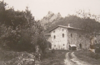
History of the "Isola di Roccalberti".
The buildings of this hamlet date back to the second half of the eighteenth century.
This emerges from some engravings on rocks.
In fact it was the custom of carving, when the construction of a building, the stones placed on top of the access points to these structures: metato (a rustic building built in the place of gathering chestnuts) houses, huts.
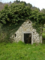
As an example, here is a picture of a ruin, a metato, abandoned and now demolished, laying on top of the stone of the access point the date 1768.
Returning to this place the people linked to these places: born or lived here.
Some do not return from a few tens of years.
These people tell:
in the post-war (the forties end) all the houses were inhabited.
Since there is little need for that time, in every house, even of modest size, several families lived.
There were three mills, thirteen metati, a bar, a shop for food and tobacconist's shop ("Sali e Tabacchi"), several huts for livestock and hay .
In all about fifty people lived.
At that time the "Isola" did not deserve the adjective of locations but was a small village.
In summer the parish of Roccalberti colonies brought here for young people to spend their holidays.
There was also a place called "Pianella" to dance with coverage of the stage.
Here were "the people" of neighbors who liked to dance ("andare al ballo").
There was someone who was playing live.
Of this there are only memories of the people.
Description of the nucleus and the surrounding settlements.
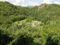
The Isola locality, which is part of the Municipality of Camporgiano, consists of two groups of houses scattered on the edge of the Edron River.
It is reachable by road SS445, it leads to the village of Vagli.
This is essentially a rural village setting of discontinuous "historical origins along the ancient Via Vandelli".
The area consists of buildings of residence, some of which are characterized by the character of architectural value.
The houses cover a pavilion were historically used for residential owner, others to agricultural activity.
The nucleus Isola denotes not so much interest for the stock as to the type of settlement structure, where, on the route of the internal road network, there was a dirt road that acted as liaison with the fraction of the country of Roccalberti.
The houses are arranged in a more or less deviates to define an urban area characterized by an average density which are identifiable hierarchies and organizations both functional morphology.
The buildings of this hamlet date back to the second half of the eighteenth century.
This emerges from some engravings on rocks.
In fact it was the custom of carving, when the construction of a building, the stones placed on top of the access points to these structures: metato (a rustic building built in the place of gathering chestnuts) houses, huts.
As an example, here is a picture of a ruin, a metato, abandoned and now demolished, laying on top of the stone of the access point the date 1768.
Returning to this place the people linked to these places: born or lived here.
Some do not return from a few tens of years.
These people tell:
in the post-war (the forties end) all the houses were inhabited.
Since there is little need for that time, in every house, even of modest size, several families lived.
There were three mills, thirteen metati, a bar, a shop for food and tobacconist's shop ("Sali e Tabacchi"), several huts for livestock and hay .
In all about fifty people lived.
At that time the "Isola" did not deserve the adjective of locations but was a small village.
In summer the parish of Roccalberti colonies brought here for young people to spend their holidays.
There was also a place called "Pianella" to dance with coverage of the stage.
Here were "the people" of neighbors who liked to dance ("andare al ballo").
There was someone who was playing live.
Of this there are only memories of the people.
Description of the nucleus and the surrounding settlements.
The Isola locality, which is part of the Municipality of Camporgiano, consists of two groups of houses scattered on the edge of the Edron River.
It is reachable by road SS445, it leads to the village of Vagli.
This is essentially a rural village setting of discontinuous "historical origins along the ancient Via Vandelli".
The area consists of buildings of residence, some of which are characterized by the character of architectural value.
The houses cover a pavilion were historically used for residential owner, others to agricultural activity.
The nucleus Isola denotes not so much interest for the stock as to the type of settlement structure, where, on the route of the internal road network, there was a dirt road that acted as liaison with the fraction of the country of Roccalberti.
The houses are arranged in a more or less deviates to define an urban area characterized by an average density which are identifiable hierarchies and organizations both functional morphology.